News
Floh-
markt
Shop
Lande-
wiesen
sis.at
0
Toggle navigation
Mückenputzer
Ausrüstung
Übersicht
Abdichten & Tuning
Abkleben
Akkus und Zubehör
Anhänger
Anschnallgurte
Aufkleber & Folien
Aufrüsten & Abschleppen
Blitzer, Strobe, Warnmarkierung
Bremsen
Cockpit
Elektronik
Erdanker
Flächen- & Staubbezüge
Flächen-Schleifsporn
Flugzeug Pflege
Haube & Fenster
Interieur
Motor, Benzin & Öl
PDA, PNA & GPS
Reifen & Zubehör
Sauerstoff
Schrauben, Muttern & Co.
Seile & Zubehör
Wasser Tanken
Werkzeug
Instrumente
Übersicht
Antennen
Einbaumaterial
ELT & PLB
Fahrtmesser
FLARM & ADS-B
Funkgeräte, Micro, ...
Höhenmesser
Kompass
Logger
LXNAV
Naviter Oudie SeeYou
Querneigungsmesser
Spot
Strom
TEK-Düsen
Temperatur-Anzeige
Transponder
Uhren
Variometer
Pilotenbedarf
Übersicht
Ausbildung
Bekleidung
Bücher
Dynafoam
Fallschirme
Flug- und Bordbücher
Headsets
Kniebretter
Landewiesen
Landkarten
Minitoiletten
Modellflugzeuge
Notausrüstung
Remove before flight
Schlüsselanhänger
Segelflugzeug Aufkleber
Software
Sonnenbrillen
Sonstiges
Taschen und Hüllen
Trinksysteme
Wärme im Flieger, SkyBoots™
Geschenke
Übersicht
DG & LS
Glasflügel
Jonkers
Schempp Hirth
Schleicher
Angebote
Neu
Flohmarkt
Übersicht
Anhänger & Aufrüsten
Binder
Bücher
Funk & Transponder
Instrumente & Zubehör
Material
Pilot
Reifen, Bremsen, Flächensporn
Schempp Hirth
Schleicher
Sonstiges
Vintage
Inhaltsverzeichnis
Alle Kategorien
Alle Artikel
0
Produkt wurde nicht gefunden!
Weiter
Login
Passwort
Anmelden
Neues Kundenkonto?
Passwort anfordern?
Warenkorb
0 Produkte
Für den Versand nach Österreich
Preise inkl. 20% MWSt (
Steuersätze
)
Inhaltsverzeichnis
Alle Artikel
Alle Kategorien
Alles Chaos
Kontoverbindung
Versand
Rücksendeformular
Kontakt
Hersteller Info
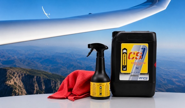
CS1 Clean & Shine in One
[
CS1 Clean & Shine in One
] in einem Arbeitsgang reinigen und polieren!
SHOP
|
MORE SHOP NEWS
Angebote
- 10%
LiFePO4 Airbatt 12Ah Premium
Artikel-Nr.: [4002]
statt 239,- € / Stk
nur
217,- € / Stk
- 6%
Trig TT23 (G) Class I
Artikel-Nr.: [3995]
statt 3.054,- € / Stk
nur
2.899,- € / Stk
- 6%
PowerFLARM Fusion
Artikel-Nr.: [3254]
statt 2.304,- € / Stk
nur
2.185,- € / Stk
- 6%
8.33 kHz - AIR COM + ACD + VT-01 Set
Artikel-Nr.: [3370]
statt 3.900,- € / Stk
nur
3.700,- € / Stk
- 4%
AIR Control & VT-01 Transponder
Artikel-Nr.: [2998]
statt 2.620,- € / Stk
nur
2.520,- € / Stk
- 2%
8.33 kHz - AIR COM + ACD Set
Artikel-Nr.: [3369]
statt 1.915,- € / Stk
nur
1.879,- € / Stk
- 26%
TQ - KTX2-S.V2
Artikel-Nr.: [3147]
statt 2.999,- € / Stk
nur
2.220,- € / Stk
- 33%
TQ - KTX2-S.V2 - BASIC
Artikel-Nr.: [3428]
statt 2.662,80 € / Stk
nur
1.800,- € / Stk
Neue Produkte
NEU
Sonnenbrille Ray-Ban 3445
Artikel-Nr.: [4007]
265,- € / Stk
Batterieabdeckung PAD65 mit MPX mittig
Artikel-Nr.: [4006]
30,- € / Stk
Batterieabdeckung PAD98 mit MPX stirnseitig
Artikel-Nr.: [4005]
36,- € / Stk
Batterieabdeckung PAD98 mit MPX mittig
Artikel-Nr.: [4004]
36,- € / Stk
- 10%
LiFePO4 Airbatt 12Ah Premium
Artikel-Nr.: [4002]
statt 239,- € / Stk
nur
217,- € / Stk
Dyneema Kevlar Schere
Artikel-Nr.: [3996]
24,50 € / Stk
- 6%
Trig TT23 (G) Class I
Artikel-Nr.: [3995]
statt 3.054,- € / Stk
nur
2.899,- € / Stk
Anhänger Abdeckhaube Heavy Duty
Artikel-Nr.: [3994]
24,- € / Stk


 Class I")


